Wednesday, August 1, 2018
Make a KML File from an OpenStreetMap Trail
Make a KML File from an OpenStreetMap Trail
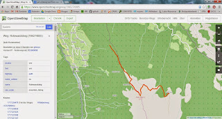
Ever wished to use a trail on OSM on your GPS or smartphone? With this neat little R-Script this can easily be done. Youll just need to search OpenStreetMap for the ID of the trail (way), put this as argument to osmar::get_osm, convert to KML and youre good to go!
# get OSM data
library(osmar)
library(maptools)
rotewandsteig <- get_osm(way(166274005), full = T)
sp_rotewandsteig <- as_sp(rotewandsteig, what = "lines")
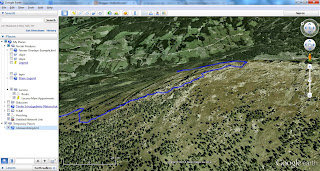
# convert to KML
kmlLine(sp_rotewandsteig@lines[[1]], kmlfile = "rotewandsteig.kml",
lwd = 3, col = "blue", name = "Rotewandsteig")
# view it
shell.exec("rotewandsteig.kml")